Mountains as Earthquake Shields: Quranic and Scientific Proof
The Quran describes mountains with four distinct attributes that modern geology has only recently confirmed: they stabilize the earth against shaking, they possess deep extensions beneath the surface, they float upon the mantle through buoyancy, and their formation is linked to the expansion of the earth’s crust. These four descriptions, all unknown in seventh-century Arabia, converge with contemporary seismic and geophysical research. This post examines the linguistic meanings of the Quranic terms rawasi (pegs) and awtad (stakes), reviews empirical studies on seismic topography effects, and evaluates the geological evidence for crustal roots and isostatic buoyancy — demonstrating that the Quran’s account of mountains is not merely metaphorical but precisely matches discoveries made only in the twentieth and twenty-first centuries.
An-Nahl 16:15 — Mountains Prevent the Earth from Swaying
وَأَلْقَىٰ فِى ٱلْأَرْضِ رَوَٰسِىَ أَن تَمِيدَ بِكُمْ وَأَنْهَٰرًا وَسُبُلًا لَّعَلَّكُمْ تَهْتَدُونَAnd He has cast into the earth firm mountains, lest it should sway with you, and rivers and roads, that you may be guided.
The classical commentators understood the word tamid (sway/shake) in this verse as referring to the earth’s instability without mountains. Al-Tabari explains in his Jami’ al-Bayan that the mountains were placed on the earth’s surface so that it would not shake or move to the right or left, but remain stable.Al-Tabari, Jami’ al-Bayan — Dar al-Tarbiyah wa al-Turath edition (20/133). This linguistic understanding establishes that the Quran attributes a stabilizing, anti-seismic function to mountains — a function that modern seismology has only recently begun to quantify.
An-Naba 78:7 — Mountains as Pegs and Anchors
وَٱلْجِبَالَ أَوْتَادًاAnd the mountains as pegs.
Rawasi (pegs) and awtad (stakes) are terms describing objects driven deep into a surface to secure what is above them. In classical Arabic, the root meaning implies fixation through depth.
The Arabic lexicographers confirm that the imagery of mountains as pegs or anchors involves penetration beneath the surface. In Taj al-Arus min Jawahir al-Qamus, the ship that tarsu (anchors) is described as one that stops and remains fixed in place.Taj al-Arus min Jawahir al-Qamus (38/150). Al-Khalil ibn Ahmad in Al-Ain defines the anchored mountain as one whose root is fixed in the ground, just as an anchored ship reaches the bottom of the water and remains unmoving.Al-Ain (7/290). Al-Sahib ibn Abbad in Al-Muhit fi al-Lughah elaborates: “The mountain anchored: its roots were fixed in the ground. Likewise the ship when it reaches the bottom of the water. The anchor: the anchor.”Al-Muhit fi al-Lughah (8/368).
These dictionary entries reveal that the pre-Islamic Arabic understanding of rawasi and awtad already contained the concept of subterranean extension — roots or anchors penetrating below the visible surface to secure the superstructure. This is not mere poetic imagery; it is a structural description that anticipates the geological discovery of crustal roots by over a millennium.
Mountains Reduce Seismic Damage in Valleys
Modern seismological research has confirmed that mountains absorb and redirect seismic waves, shielding adjacent valleys from the full force of earthquakes. Topography demonstrably reduces ground motion in valleys while amplifying it at mountain ridges and peaks, precisely matching the Quranic description of mountains preventing the earth from “shaking with you.”
In 2019, a research team led by Dr. Mark van der Meijde at the University of Twente published a study on the 2015 Gorkha earthquake in Nepal. They found that the Kathmandu Valley experienced surprisingly weak ground shaking despite its proximity to the magnitude 7.8 event.
[!research] van der Meijde et al. (2019) — The Influence of Surface Topography on the Attenuation of Ground Shaking in the Kathmandu Valley
“It remains elusive why there was only weak and limited ground shaking in Kathmandu valley during the 25 April 2015 Mw 7.8 Gorkha, Nepal, earthquake. Our spectral element numerical simulations show that, during this earthquake, surface topography restricted the propagation of seismic energy into the valley. The mountains diverted the incoming seismic wave mostly to the eastern and western margins of the valley… Modeling of alternative earthquake scenarios of the same magnitude occurring at different locations shows that these will affect the Kathmandu valley much more strongly, up to 2–3 times more, than the 2015 Gorkha earthquake did. This indicates that surface topography contributed to the reduced seismic shaking for this specific earthquake and lessened the earthquake impact within the valley.”
Similarly, in 2009, Xianlong Li, Dmitry Komatich, and colleagues investigated seismic wave propagation in northern Taiwan.
[!research] Li, Komatich et al. (2009) — Effects of Topography on Seismic-Wave Propagation
“Topography influences ground motion and, in general, increases the amplitude of shaking at mountain tops and ridges, whereas valleys have reduced ground motions, as is observed from data recorded during and after real earthquakes and from numerical simulations.”
The researchers note in their introduction that this phenomenon has been documented in past earthquakes, including studies by Hartzell et al. (1994) and Spudich et al. (1996). Their simulations for the Taipei Basin show that when topography is accounted for, the impact of an earthquake on the basin is greatly reduced — and vice versa.
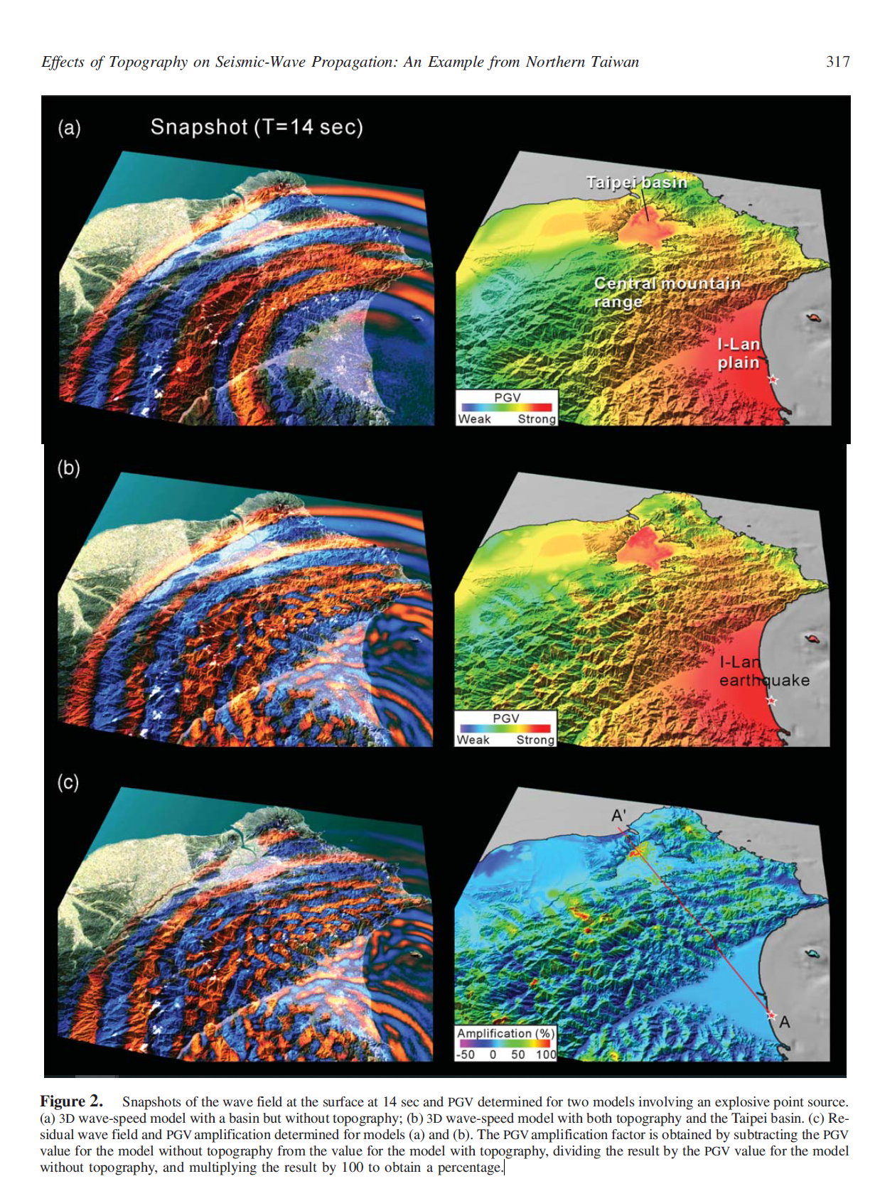
The topographic model demonstrates that seismic energy is concentrated at elevated terrain. The complementary velocity model for the same terrain confirms that valleys experience negative PGV amplification — meaning the ground motion is actively dampened.
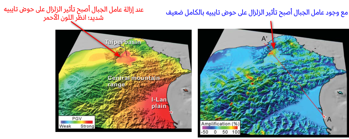
Figure 2c illustrates that PGV is increased at mountain tops and ridges, while valleys usually have a decreased PGV, that is, a negative PGV amplification factor. This phenomenon is also addressed by Lee et al. (2008, 2009).Li, Komatich et al. (2009), Effects of Topography on Seismic-Wave Propagation.
Isostasy: Mountains Float on the Mantle
The stability of mountains is not merely a matter of weight pressing down; rather, mountains maintain equilibrium by floating upon the denser mantle beneath them. This principle — known as isostasy — means that any increase or decrease in a mountain’s mass causes it to sink or rise like a vessel in water, preserving the balance of the earth’s crust.
[!science] Stephen Errell — Physical Geology
“Isostasy refers to the way in which solid floats above liquid.”
More precisely, the earth’s lithosphere floats upon the semi-fluid asthenosphere of the upper mantle. Amruta Patel explains this in a 2023 geography note:
[!science] Amruta Patel — Theory of Isostasy (2023)
“The theory of isostatics is a fundamental principle in explaining the buoyancy of the lithosphere, which floats on a liquid layer (the upper part of the mantle). It is similar to something floating on water; buoyancy depends on the volume and mass of the displaced water. The Earth’s crust floats at a certain height depending on its thickness and density in a way that keeps it in equilibrium. Thicker and more mountainous areas of the Earth’s crust will sink deeper into the fluid in the upper part of the Earth’s mantle. At a certain depth known as the ‘equilibrium depth,’ the pressure exerted by the column of rock (the root) is equal everywhere (of the fluid) regardless of the topography of the surface. When any weight is added or removed from the Earth’s crust due to, for example, erosion, sedimentation, or erosion or accumulation of ice, the crust balances itself up or down until equilibrium is achieved; this process is called isostatic adjustment… When erosion occurs in the mass of the mountain over time, the lower crust (the root) rises to cause balance.”
[!science] Harry Fielding Reid — Isostasy and Mountain Ranges (1911)
“If a large amount of matter is removed from the earth… If a part of the crust is bent and compressed as a result of tangential pressure exerted on it and the material on that surface increases, the added weight will result in… If by erosional transportation a large quantity of material is removed from a high land and deposited in the oceans, then the increase of weight under the ocean and the decrease under the mountains will, as Major Dutton explained, set up a subterranean counter flow, which will restore the equality of material in the segments. If by the exercise of tangential forces a portion of the earth’s crust is compressed and folded and the quantity of material in the segment thus increased, the added weight will cause a slow sinking of the region and material will flow out from below and reduce the mass of the segment to its proper value.”
The Quran expresses this buoyant equilibrium with the word rasuwan (anchored), repeatedly describing mountains as “firmly set” — a term that implies both fixation and floating stability. The linkage between mountain firmness and crustal balance is not metaphorical; it is a precise description of isostatic equilibrium.
Geological Evidence: Mountains Have Deep Crustal Roots
The description of mountains in the Quran as pegs and anchors has been supported by scientific studies describing mountains as having roots under the Earth’s surface and floating on top of the mantle magma. The crust beneath mountains resembles icebergs with high peaks but massive roots below the waterline — an analogy confirmed by seismic and gravitational data.
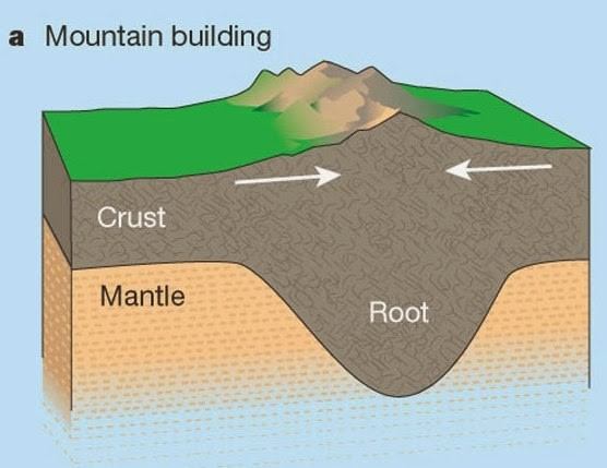
Geologists Bryce, Frank, and Raymond write in their textbook The Earth that “a mountain three or four miles high is capable of forming a root that may reach a depth of thirty or forty miles in the surrounding mantle.” In Anatomy of the Earth, geologist Andrew Kellow states that “this shaft of mountain-root serves to support the weight of the overlying mountain, thereby establishing equilibrium or, in the language of the geologist, an isostasy.” Tarbuck and Lutjens in Earth Science confirm that “the existence of these roots has been confirmed by seismic and gravitational data.”
[!science] Frank Pierce & Weymond Silver — Earth
“Continents float because of the large, low-density crust that protrudes above the denser mantle, which causes the buoyancy, as in Figure 19.6. Note that the crust is thicker.”
They further note that mountain formation and sinking are dynamically linked: “Isostasy also implies that as a large mountain range forms, it slowly sinks under gravity and the crust bends downward. When enough of a root bulges into the mantle, the mountain floats.” Brian Skinner and Stephen Porter in Physical Geology employ the iceberg analogy explicitly: “The crust beneath the mountains resembles icebergs with high peaks, but with massive roots below the waterline. The accuracy of this analogy is demonstrated by the gravity profile across the United States, shown in Figure 16.18c. Negative gravity anomalies are observed where the crust is thickest. These anomalies are caused by the roots of low-density rock beneath the mountains.”
[!science] Gary Smith & Arora Boone — How Does the Earth Work?
“Airy’s hypothesis predicts that the base of the crust is deepest beneath areas of highest elevation; in other words, mountains should have roots in the mantle… Seismic data demonstrate the presence of thick roots of crust projecting downward into the mantle beneath mountains as predicted by Airy’s model.”
Christina Reed in Earth Science notes that “Wegener preferred to combine several models; to support the theory of continental motion he relied on the crust.” Kurt Stuwe in Geodynamics of the Lithosphere summarizes: “Seismic studies in many mountain belts show that most regions of high surface elevation are indeed compensated by significant roots at depth.” Ted Nield explains the gravitational evidence: “Mountains, Airy said, exert less gravitational pull than they should do because they have roots… They stand proud, but only because they have much larger roots below.”
[!science] M. J. Selby — Waning Buoyancy in the Crustal Roots of Ancient Mountains (2002)
“Mountains are formed by the collision of lithospheric plates; the uplift of the Earth’s surface increases the thickness of the crust, and the buoyancy of these crustal roots is thought to support the topography of mountains. Once crust formation ceases, continued erosion will erode the surface topography… In ancient mountain belts, the ratio between surface erosion and root thickness is small compared to modern mountains. The best explanation is in light of gravity data that the buoyancy of the root decreases with time, beginning with the last mass-building process of the mountain, which is done by long-term cooling (of lava and magma). The approximate equilibrium between the mountain and the root mass indicates that the continental lithosphere has remained thin enough to allow the roots to emerge in response to the erosion of the Earth’s surface over millions of years.”
Walter Butcher concludes in The Crust of the Earth: “This indeed suggests the existence of a mountain ‘root.’ Seismic studies provide a clinching proof….the Alps do have a granitic root.” David James affirms that “active mountain belts have crustal ‘roots’ that gravitationally balance the high topography.”
Could the Prophet Have Known This Through Analogy?
Some argue that the Prophet ﷺ could have inferred the stabilizing role of mountains by comparing them to heavy objects in everyday life — buildings, weights on paper, nails in wood, or large carts — and that simple Bedouin observation suffices to explain four precise geological facts: that mountains protect adjacent land from shaking, that they have deep roots, that they float on magma, and that their formation is tied to crustal expansion.
Second: The analogy with a weight placed on paper fails for the same reason. Only the portion of the paper directly under the weight is held down; the rest of the sheet can be moved freely without disturbing what is under the weight. If the Prophet had observed this, he would not have concluded that mountains shield surrounding valleys.
Third: The analogy with a piece of wood carrying a heavy load only works if the load is far heavier than the wood itself, or if a nail is involved. A mountain is not heavier than the entire earth; the vast surface area of the earth dwarfs the mass of all mountains combined. The Prophet traveled extensively and knew beyond dispute that the area free of mountains is dozens of times greater than the area covered by mountains. Intuitively, their weight is insufficient to stabilize such an immense surface.
Fourth: The nail or peg analogy — which the Quran explicitly uses — introduces a completely different justification from the weight analogy. Once the weight argument collapses, the objector shifts to claiming the Prophet imagined mountains as nails driven into the ground. But what observation would lead him to suppose that mountains have extensions deep below the surface? If one places a large stone on the ground, it sinks only a few centimeters. The penetration of a nail into wood is long relative to its diameter, whereas the sinking of a heavy object into soil is shallow and negligible. No amount of weight placed on the ground produces a penetration comparable to a nail’s breach. Thus the nail analogy cannot be derived from observing weights.
Fifth: Even if one grants that the Prophet imagined mountains sinking deeply like nails, this requires a chain of unstated assumptions: that he imagined the earth to be shallow, like the proportion between a nail and a plank of wood; that he imagined distinct layers in the earth, since a nail fixes two layers together; and that he knew the earth had layers from wells, deep trenches, and the sea depths known to fishermen and divers. Each assumption depends on the next, and the chain grows progressively weaker. The Prophet knew of deep wells such as the Barhout Well in Yemen, and he knew of the sea depths from the experience of pearl divers — yet none of these observations suggest that mountains penetrate dozens of miles into layered strata.
Sixth: Heavy objects are a cause of disturbance, not stability, when they themselves are shaken. If a weight rests on paper and the weight is moved, the paper beneath it is disturbed more severely than if a finger lightly touched the sheet. If a stone is moved, the soil beneath it is disturbed; the weight amplifies the disturbance. The objector might cite a cart shaken empty versus full, but the reason the empty cart shakes more severely is not because emptiness causes shaking, but because the shaker’s ability to impart force is diminished by greater mass. If the same force were applied, the loaded cart would shake more violently because the boxes would strike one another upon returning to stability. The presence of weight, when its carrier shakes, increases the shaking — it does not decrease it.
Seventh: The vast height and slopes of mountains distribute seismic waves over an enormous area, allowing the wave to be absorbed completely so that its repercussions die before reaching the valleys. This is unlike a small cart, where the load would collide and multiply the disturbance. The fact that mountains absorb rather than amplify seismic energy is unique to their scale and structure — not observable in any everyday object the Prophet might have encountered.
Eighth: If the objector appeals to an extremely large, heavy wooden cart as the source of inspiration, this introduces a sixth assumption that is itself controlled by further problems. The Arabs of the desert had no horse-drawn carts; the terrain was suitable only for camel hooves. An Arab would not foolishly build a heavy wooden cart that would sink in the sand before moving. To suppose the Prophet saw such a cart requires a seventh assumption — that he observed it in the Levant during his travels — and an eighth assumption — that he noticed the phenomenon, forgot it for twenty years, and then recalled it when describing mountains. The series of assumptions increases, and with it the weakness of the argument.
Ninth: If the stabilizing role of mountains is so simple that a Bedouin could deduce it from superficial contemplation, why did it elude the great geologists of the Renaissance in the seventeenth, eighteenth, and nineteenth centuries? How did a layman from the lowest parts of the earth in terms of knowledge notice what the highest specialists in the most brilliant ages of science failed to see? Even if we accept this impossibility once, is it reasonable for it to be repeated a second time for the Quranic description of mountains as pegs with deep roots? A third time for the fact that mountains float upon a sea of magma? A fourth time for the relationship between mountain formation and the expansion of the earth? Four independent geological facts, each beyond the science of their age, cannot be explained by a single naive analogy.
The Quran describes mountains with four attributes — stabilizing the earth against shaking, possessing deep subterranean roots, floating upon the mantle through isostatic buoyancy, and forming in conjunction with crustal expansion — each of which has been independently verified by modern geology and seismology. The linguistic evidence from classical Arabic dictionaries confirms that rawasi and awtad always implied rooted fixation. Empirical studies demonstrate that topography reduces seismic damage in valleys. Geophysical research confirms that mountains have low-density crustal roots extending tens of miles into the mantle. And the theory of isostasy reveals that these mountains float in gravitational equilibrium. The convergence of four distinct scientific facts with Quranic descriptions that predate their discovery by over a millennium cannot be explained by analogy, observation, or chance.
Sources
- Al-Tabari, Jami’ al-Bayan — Dar al-Tarbiyah wa al-Turath edition (20/133).
- Taj al-Arus min Jawahir al-Qamus (38/150).
- Al-Ain (7/290).
- Al-Muhit fi al-Lughah (8/368).
- van der Meijde, M. et al. (2019). The Influence of Surface Topography on the Attenuation of Ground Shaking in the Kathmandu Valley during the 2015 Gorkha Earthquake, Nepal. Abstract.
- Li, X., Komatich, D., Huang, B.-S., & Tromp, J. (2009). Effects of Topography on Seismic-Wave Propagation: An Example from Northern Taiwan. Abstract.
- Li, X. et al. (2009). Figure 2c and velocity model analysis.
- Earle, S. Physical Geology. “Isostasy refers to the way in which solid floats above liquid.”
- Patil, A. (2023). Theory of Isostasy — Geography Notes, Oct 4.
- Reid, H. F. (1911). Isostasy and Mountain Ranges. Proceedings of the American Philosophical Society, Vol. 50, No. 200.
- Tarbuck, E. J. & Lutgens, F. K. (1982). The Earth. p. 158.
- Kellow, A. (1968). Anatomy of the Earth. New York: McGraw-Hill. Translated by J. Moody Stuart. p. 222.
- Tarbuck, E. J. & Lutgens, F. K. (1982). Earth Science. 3rd ed. Columbus: Charles E. Merrill. p. 157.
- Press, F. & Siever, R. (2nd ed.). Earth. p. 490.
- Press, F. & Siever, R. (2nd ed.). Earth. p. 490.
- Skinner, B. J. & Porter, S. C. Physical Geology. p. 469.
- Smith, G. & Boone, A. (2010). How Does the Earth Work? 2nd ed. Pearson. pp. 306–307.
- Reed, C. Earth Science. p. 39.
- Stuwe, K. (2nd ed.). Geodynamics of the Lithosphere. Springer. p. 164.
- Nield, T. Mountain Roots. https://www.geolsoc.org.uk/Education…Mountain-Roots
- Fischer, K. M. (2002). Waning Buoyancy in the Crustal Roots of Ancient Mountains.
- Bucher, W. H. The Crust of the Earth. p. 35.
- James, D. E. (2002). Earth Science: How Old Roots Lose Their Bounce. Nature 417(6892).